Fairy Meadows & Nanga Parbat Base Camp Guide for 2023
JUMP TO: PROS & CONS / ITINERARY / ACCOMMODATION / WHEN TO GO / HOW TO GET THERE / TRAVEL INSURANCE / MAPS
Author: Sam Brilleman
Keen for a perilous ride along one of the most dangerous roads on the planet? How about breathtaking views of the one of the world’s top ten biggest mountains? Well then perhaps Fairy Meadows should be on your radar — it’s hiking and adventure all wrapped up in one trip!
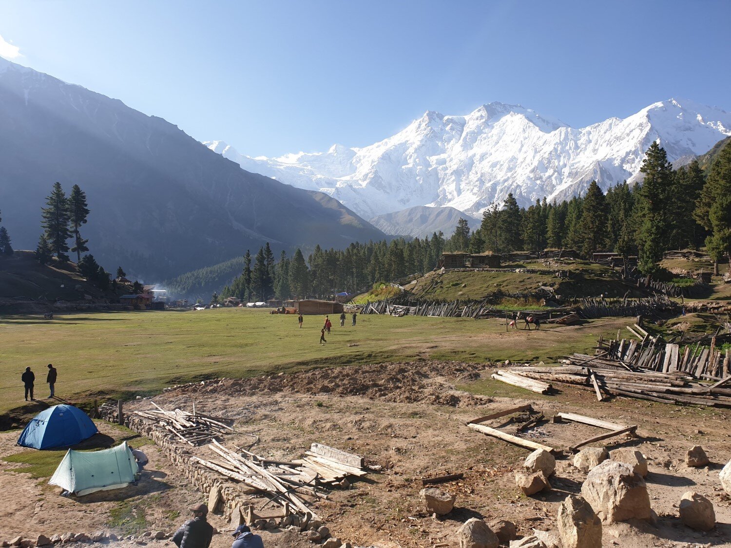
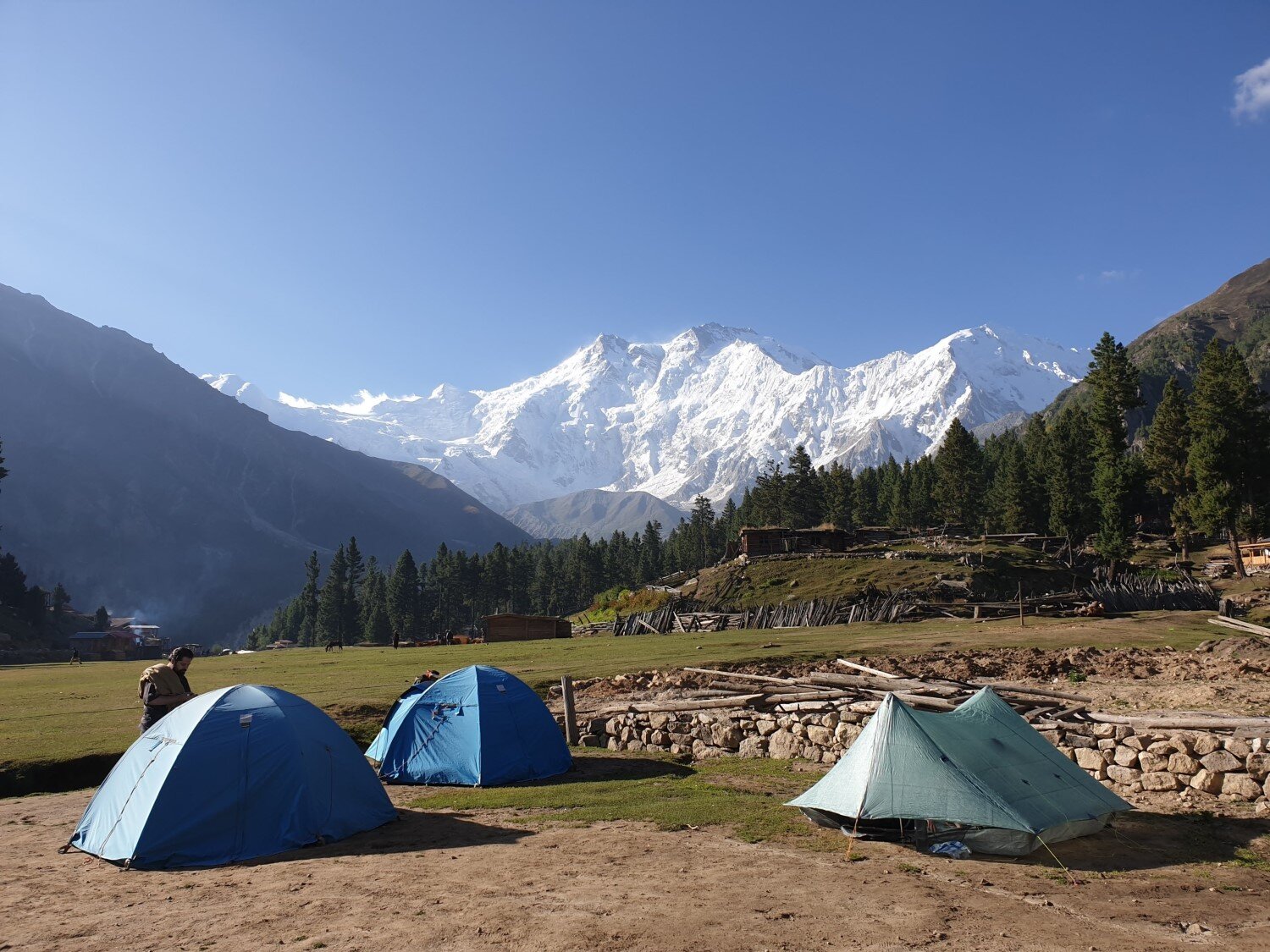
Fairy Meadows is one of the most popular nature destinations in Pakistan, and rightly so. This beautiful alpine meadow is set with an impressive backdrop — the mighty Nanga Parbat — 9th highest mountain in the world. And it is Nanga Parbat that most people come to see.
The views of Nanga Parbat from Fairy Meadows are just stunning.
Standing tall at 8,126 metres Nanga Parbat is located in the north of Pakistan at the westernmost end of the Himalayas. It is the second highest mountain in Pakistan after K2. It is huge, majestic, and an impressive sight to behold close up.
Nanga Parbat is known to be notoriously difficult and dangerous to climb. It has claimed the lives of many mountaineers over the years, leading to its nickname Killer Mountain.
Fortunately for those of us who are more into hiking than mountaineering, it is relatively easy to get to the base camp on the northern side of Nanga Parbat. There you can soak in dramatic views of both the Raikot Glacier and Nanga Parbat’s northern face.
The trail to Nanga Parbat Base Camp follows alongside the Raikot Glacier, offering mind-blowing views the entire way!
In this guide I provide all the info you need for a trip to Fairy Meadows, as well as the day hike that takes you from Fairy Meadows to Nanga Parbat Base Camp.
Many visitors stop at Fairy Meadows and do not venture further. However the day hike from Fairy Meadows to Nanga Parbat Base Camp is well worth it. The views along the trail are stunning and Nanga Parbat’s northern face is all the more impressive close up.
In short… this mountain is EPIC!

PROS
Amazing alpine scenery, including seeing the 9th highest mountain in the world close up!
A variety of accommodation options available at Fairy Meadows
CONS
Jeep track to Fairy Meadows is not for the faint hearted
Fairy Meadows is experiencing issues with rubbish and litter
Fairy Meadows can be popular in peak season (June, July, August) and long weekends
ITINERARY
Getting to Fairy Meadows and/or Nanga Parbat Base Camp essentially involves the following sections:
Raikot Bridge to the trailhead near Tattu Village: 90-120 mins jeep ride.
Trailhead to Fairy Meadows: 90-120 mins uphill hike (porters and horse rides available).
Fairy Meadows to Beyal Camp: 60-90 mins relatively easy hike.
Beyal Camp to Raikot Glacier Viewpoint: 60 mins relatively easy hike.
Raikot Glacier Viewpoint to Nanga Parbat Base Camp: 90-120 mins moderately hard hike (some narrow parts on the trail, and the last 30 mins is very steep).
I describe each of these sections in more detail below. Note that accommodations (cabins and camping, details below) are predominantly located at Fairy Meadows, although there is some accommodation located at Beyal Camp as well.
RAIKOT BRIDGE SERVICES
Raikot Bridge is a small junction village located on the Karakoram Highway. There isn’t much there — a few hotels, and a couple of small shops and restaurants.
However it is the starting point for the 4WD track to Fairy Meadows. The 4WD track is known as “Fairy Meadows Road” and it takes you as far as a drop-off point near Tattu village, where the hiking trail to Fairy Meadows begins.
You will find a number of jeeps located either at the start of Fairy Meadows Road or waiting in the carpark just next to the Shangrila Hotel.
These local jeeps (with driver) are the only way to travel on Fairy Meadows Road. You are not allowed to take your own car and for good reason — see details about the road condition below!

The trip to Fairy Meadows involves a 2 hour jeep ride along some pretty sketchy terrain!
RAIKOT BRIDGE TO TRAILHEAD
TRANSPORT: Jeep
DURATION: 90-120 mins
DIFFICULTY: Easy but scary
The jeep ride taking you to the Fairy Meadows trailhead is quite an adventure in itself. The journey consists of a perilous two-hour jeep ride along what is considered one of the most dangerous roads in the world.
The vast majority of the road is narrow, bumpy, and winds along the hillside high above a dramatic gorge. In addition the road is essentially one jeep-width but carries traffic in both directions. This can make for a very harrowing ride, especially when it comes time for jeeps to overtake one another.
The locals like to claim that the jeep drivers are highly trained and know exactly what they are doing. However our definitions of “highly trained” probably differ and, at the end of the day, a narrow rough track with a sheer cliff on one side doesn’t allow much room for error regardless of training!
The road to Fairy Meadows is pretty narrow, especially when it comes time for two vehicles to pass in opposite directions!
There is no denying that if your jeep driver were to make a mistake and slip off the road edge then everyone in your jeep would — without a doubt — perish. I’m not sure how many accidents happen on this road (the locals claim not many). But I’d be pretty confident the number isn’t zero.
In any case, if you survive, it will likely be one of the most exciting things you do in Pakistan!
But don’t be fooled by the popularity of Fairy Meadows — if you are someone who don’t like scary roads, has a fear of heights, or has an aversion to danger then you should probably reconsider.
JEEP COSTS: As at September 2019 the standard price for a jeep was 8100 PKR (approx. US $50). This is for the return trip and can be shared between as many people as you can manage to fit in the jeep: 2 people is luxury, 4 is reasonably comfortable, >4 is a squash but possible.
Waiting in a traffic jam as the drivers try and work out how to allow the oncoming jeeps to pass.
We had 2 people on the way up and 6 people on the way down (some guys whose jeep didn’t show up hitched a ride down with us) and it was ok. The local jeep drivers here have quite a monopoly so it doesn’t seem to be possible to bargain for a cheaper price, but you can always try!
They usually will ask you to pay 5100 PKR upfront for the journey up the hill to the drop off point. They will then give you a little slip of paper with a prearranged time at which they will collect you for the journey down.
Everyone that goes up together in the jeep must also come down together! So if you arrange to share a jeep on the way up, then you must make sure that those people are planning to leave on the same day/time as you plan to.
The same driver will then meet you at the prearranged time and collect the remaining 3000 PKR after you arrive back at Raikot Bridge.
TRAILHEAD SERVICES
The hiking trail to Fairy Meadows begins where the jeep drops you off. At the drop off point there is a small tuck shop selling water and snacks.
Once you leave the drop off point you will cross a stream and walk about 100 metres to reach an area with some toilets, accommodation (“hotel”) and a police checkpoint. There is running water available from a sink out the front of the hotel, but I’d probably treat it before you drink it (or buy bottled water).
At the police checkpoint foreign tourists will be asked to sign in. This is a straightforward formality (like everywhere else in Pakistan) and should only take a couple of minutes. The police were very friendly.
When we did this hike it was early September 2019 and even by 3pm in the afternoon there had been just five foreigners check in that day, yet hundreds of Pakistani tourists — so foreign travellers are still relatively rare in Pakistan!
Many blog posts we read before travelling there said that foreigners were given a police escort for their entire trip to Fairy Meadows. This was due to an infamous shooting that happened at Nanga Parbat Base Camp back in 2013. However when we visited there wasn’t any mention of a police escort — it seems that (unnecessary) formality has now been done away with.
The cool little hut that serves at the police checkpoint.
TRAILHEAD TO FAIRY MEADOWS
TRANSPORT: Hiking (porters and horse rides available)
DURATION: 90-120 mins
DIFFICULTY: Moderate (well groomed trail but quite steep uphill)
The hiking trail to Fairy Meadows is uphill, but otherwise pretty straightforward. Navigation isn’t a problem — there is just one obvious trail winding its way along the steep hillside that forms the west bank of the Raikot River. There are a couple of small shops along the trail where you can buy water or snacks if you need.
For most people it will take 1.5 - 2 hours of uphill walking to reach Fairy Meadows.
Porters are available for carrying gear between the jeep drop off point and Fairy Meadows. Some domestic Pakistani tourists seemed to bring all kinds of shit for the porters to carry, including music speakers and rolling wheel suitcases. I felt pretty bad for these porters — passed a square suitcase with wheels but no handles! If you are bringing too much stuff to carry yourself, then at least bring it in a backpack. For large loads the porters have donkeys.
Or for those who aren’t particularly keen on hiking at all there are horses available for hire. You can sit of the horse while its owner leads it up the trail. (Yawn…)
The scenery on this section of trail isn’t particularly impressive until the last 15 minutes or so, at which point Nanga Parbat comes into view. And once you reach Fairy Meadows you are rewarded with even more stunning views of Nanga Parbat in the distance.
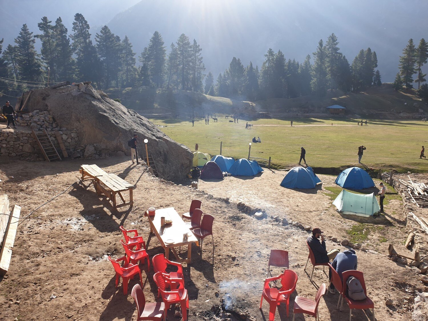
Once you are at Fairy Meadows there are several accommodation and restaurant options (described below) scattered across the area. They are all within a few minutes walk of each other. There are also several tuckshops selling bottled water, snacks, and other basic supplies.
SIDE NOTE: This trail — and Fairy Meadows itself — is littered in rubbish. This is a common theme throughout Pakistan and South Asia, but it is all the more sad in this stunning mountain environment. We filled the extra space in our backpacks by collecting rubbish as we made our way up the trail. We also tried to explain to the locals why rubbish isn’t a good thing — many of them told us to just throw the stuff we were picking up back on the ground. Please consider doing the same wherever possible. It is going to take a lot of action and education to fix this issue.
FAIRY MEADOWS TO BEYAL CAMP
TRANSPORT: Hiking
DURATION: 60-90 mins
DIFFICULTY: Easy to moderate (relatively flat trail)
The majority of visitors make it to Fairy Meadows and don’t venture any further. This is a blessing for those who do want to reach Nanga Parbat Base Camp because it means the trail beyond Fairy Meadows is less populated and more pristine.
After leaving Fairy Meadows the trail wanders through forest high up on the hillside above the western bank of the Raikot Glacier. The trail offers numerous glimpses of the mighty Nanga Parbat in the distance.
The path to Beyal Camp offers some stunning glimpses of Nanga Parbat in the distance.
It will take about 60 minutes of walking to reach the start of Beyal Camp. Beyal Camp is a small village at which the local villagers have built a restaurant, some cabins and campsite.
There isn’t any electricity at Beyal Camp, but there is a lot more solitude and peace than at Fairy Meadows itself. We didn’t stay at Beyal Camp, but we kind of wish we did.
Beyal Camp is spread along the valley and it will take you about 15 minutes to walk through the village.
The view of the valley as we start to enter Beyal Camp.
BEYAL CAMP TO RAIKOT GLACIER VIEWPOINT
TRANSPORT: Hiking
DURATION: 60 mins
DIFFICULTY: Easy to moderate (gradual uphill trail)
After leaving Beyal Camp you continue to meander up the valley through the sparse trees. The trail is easy to follow and has only a slight uphill gradient. After about 45 to 60 minutes you should reach a viewpoint on the edge of the Raikot Glacier.
The viewpoint provides amazing views along the Raikot Glacier and views towards the mountains — including Nanga Parbat itself (8126m) as well as surrounding peaks such as Chongra Peak (6830m), Raikot Peak (7070m), and Ganalo Peak (6606m).
The viewpoint seemed quite a popular place when we were there (perhaps 15 people were resting and eating snacks etc) and many only came as far as the viewpoint and then turned back to Fairy Meadows.
When we were there (Sept 2019) there weren’t any facilities available at the viewpoint. However, there were a number of local men building what is likely to be a restaurant or tuckshop. So if you are travelling there in 2020 or after then I’d expect you will probably see some availability of food, supplies or maybe even accommodation at the Raikot Glacier Viewpoint.
This viewpoint is about 60 minutes beyond Beyal Camp and a popular finishing point for those who don’t want to do the final push along the (more narrow) trail to the base camp.
RAIKOT GLACIER VIEWPOINT TO NANGA PARBAT BASE CAMP
TRANSPORT: Hiking
DURATION: 90-120 mins
DIFFICULTY: Moderately hard (trail is narrow at times, last 30 minutes is steep uphill)
After you leave the Raikot Glacier Viewpoint the trail conditions change quite dramatically. Instead of meandering through the sparse woods you begin to traverse along the edge of the glacial valley. You are now on a narrow trail built into the relatively steep and unstable hillside.
It isn’t particularly dangerous and not at all technical (assuming you travel when there isn’t snow).
Nonetheless we did meet people who felt uncomfortable traversing along the steep bank and chose not to continue along this part of the trail.
In addition you are no longer protected by the shelter of the trees or narrow part of the valley — so this part of the trail is much more exposed. So I’d only suggest continuing along this part of the trail if the weather is reasonable.
This young boy was bringing a brave horse across a rather raging stream.
There are also a couple of stream crossings you have to deal with. The streams were raging at the time we were there, even though it was late summer! So my guess is that they are raging all the time!
Fortunately the locals have constructed makeshift bridges to get across the streams — they don’t look particularly sturdy, but they did the trick.
In fact we even saw a young boy bringing a horse across one and a shepherd bringing about 50 goats across another!
After about 60 minutes of walking through the exposed rocky terrain you will turn uphill and approach a flat grassy area. From there you have another 15-30 minute pinch climb up a steep hill with grass and various tussocks.
Note that this last part of the trail doesn’t coincide with the route shown on the Maps.me mapping app — that is, the trail turned up the hill and approached the flat grassy area, whereas the trail shown on Maps.me kept following the western side of the glacier.
The goats wait patiently to cross the bridge!
All up, it should take you about 90-120 minutes to get to the base camp / tuck shop from the Raikot Glacier Viewpoint. We finished our hike at the tuckshop shown in the photo below. It had pretty great views and a local guy serving chai and dahl, so it seemed an ideal place for us to rest and turn around.
However, several maps show the Nanga Parbat Base Camp in a slightly different location to the tuck shop — and there is apparently two actual base camps anyway — a winter and a summer one!
So whether the tuckshop is actually located at the “base camp” remains a mystery to me. But nonetheless it is a great place to finish your hike.
Some others that were there went off and explored a bit further off trail — towards the ridge line in the photo below — and they said it was worthwhile. So you can do the same if it tickles your fancy.
The exact location of the “Base Camp” seemed to be a bit open to debate, but this “Nanga Parbat Tuckshop” seemed like the ideal final destination for the hike.
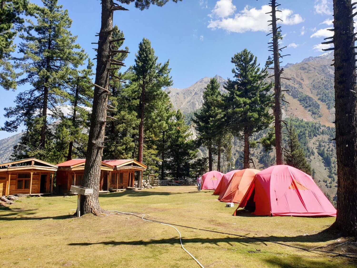
ACCOMMODATION
There are a number of privately owned accommodation options. These predominantly consist of cabin style accommodation as well as grassy areas for camping.
The majority are located in Fairy Meadows, however there are also cabin and camping options at Beyal Camp (about a 45 minute hike beyond Fairy Meadows).
I’ve provided details on several accommodation options below. However my list is not exhaustive! At both Fairy Meadows and Beyal Camp there appeared to be new accommodations being built at the time we visited. So, if you have recommendations on places I might have missed or opinions on the places I’ve list below, then do reach out!
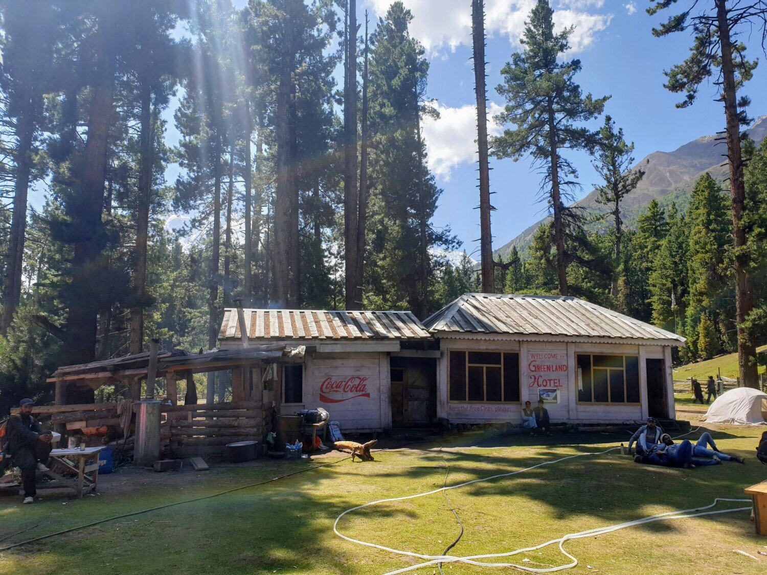
GREENLAND HOTEL (FAIRY MEADOWS)
LOCATION & VIBE: Greenland Hotel is located in the centre of Fairy Meadows. It consists of one central block with the kitchen and restaurant, as well as a number of detached cabins and a grass area for camping.
The owner seems pretty nice. He also offered the cheapest prices (for both the room and camping) without us having to barter.
However, Greenland Hotel seemed like a popular place for large groups during busier periods. We were there on a busy weekend and there were people playing music until midnight, making it hard to find peace and quiet in the campsite.
RESTAURANT: The restaurant at Greenland Hotel seemed like a pretty smooth operation (there seemed to be specific people employed as cooks, wait-staff, etc). It seemed capable of serving food for large groups too.
ROOMS: The cabin we viewed at Greenland Hotel was probably the nicest out of the three rooms we looked at in Fairy Meadows — it was slightly nicer than the hotel room at Shambala and much nicer than the cabin at Raikot Serai.
We were quoted 3000 PKR / night for a cabin with ensuite (toilet and running water, but no shower), but heard of people paying as little as 1000 PKR on the shoulder season. I’m not sure if all of the rooms have an ensuite or not.
Unfortunately none of the cabins have a direct view of Nanga Parbat because of tree cover.
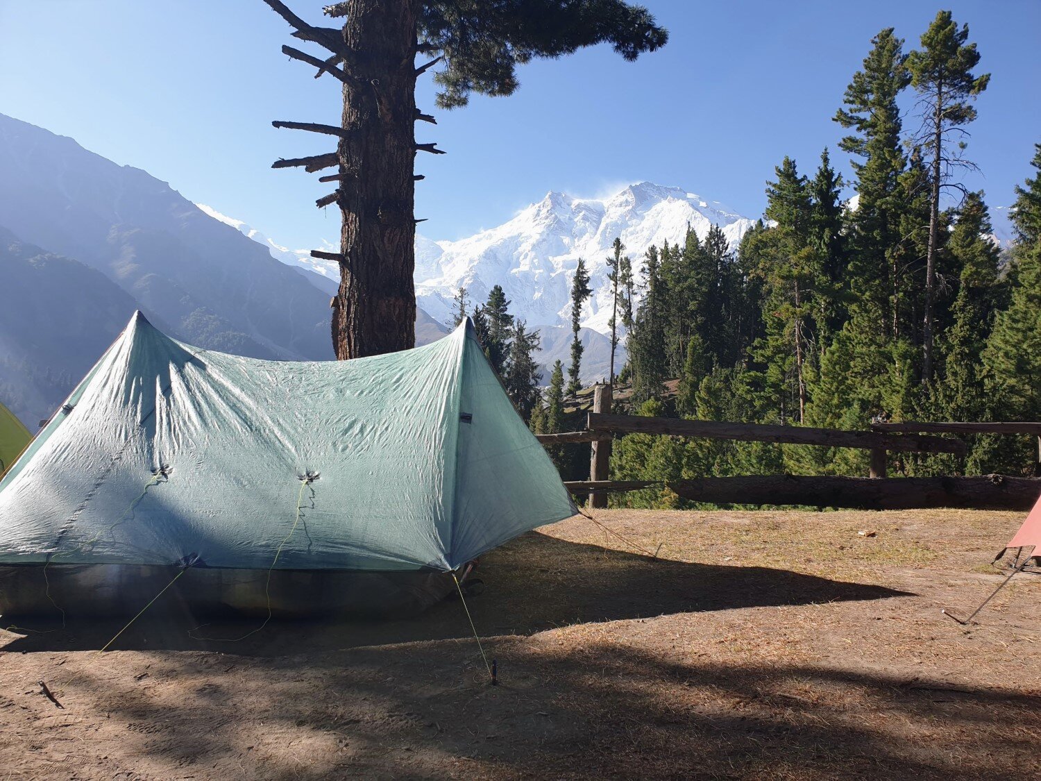
CAMPING: We were quoted 1000 PKR / night for a campsite. Some of the camping spots provide direct views of Nanga Parbat (see photos below). Campers have access to one — pretty dirty — squat toilet.
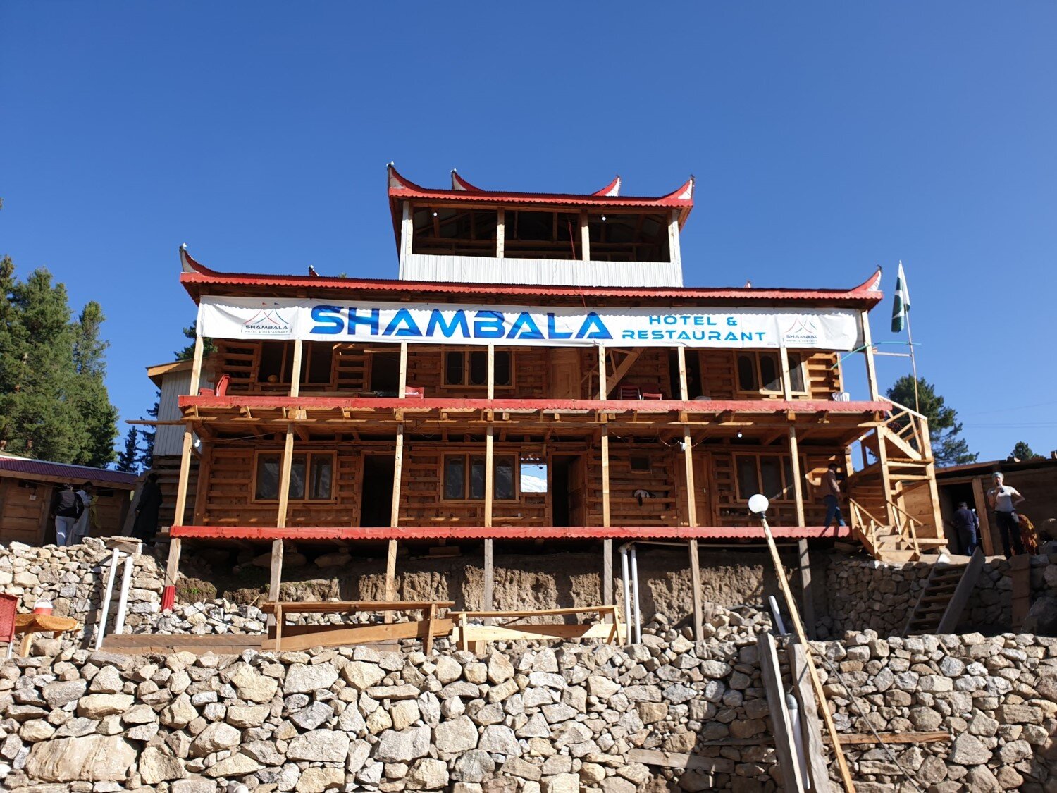
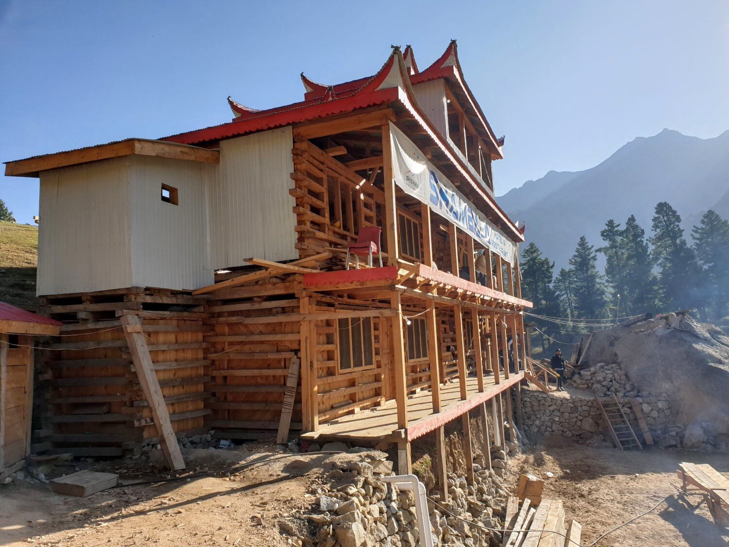
SHAMBALA HOTEL (FAIRY MEADOWS)
LOCATION & VIBE: Shambala Hotel is located about 200 metres away from the majority of the other accommodation options. This means that it can be a bit more peaceful than for example Greenland Hotel or Raikot Serai.
The owner is amazingly kind and friendly. He was very welcoming, made great conversation, and even allowed us to camp for free. The entire property (including the camping spots) has direct views of Nanga Parbat (see the photos below). There is also an outdoor area with a bonfire.
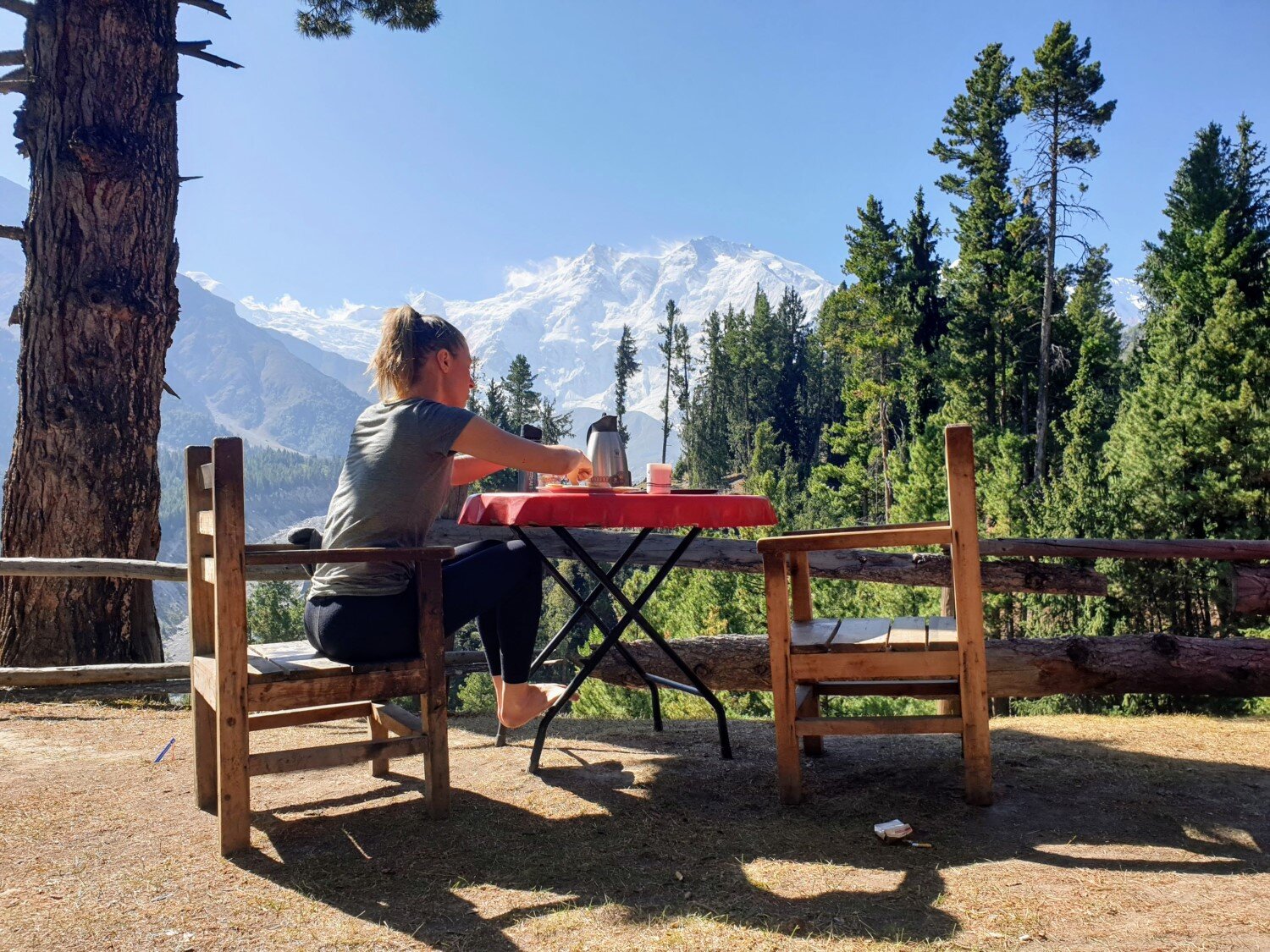
RESTAURANT: Shambala has a small kitchen where the owner can provide you with breakfast and/or dinner. It is a cosy kitchen that makes a great place to hang out in the evening and socialise. Food seemed to be prepared on a sort of “ad hoc” basis (even the guests were helping out with the cooking!).
ROOMS: The rooms were pretty basic but reasonable — the one we saw had two single mattresses on the floor and an ensuite with toilet and running water (but no shower). We were quoted 4000 PKR / night for the room.
CAMPING: The camping spots are just on the dirt/grass out the front of the hotel. There are three squat toilets for use by campers and those who do not have an ensuite toilet in their hotel room.
RAIKOT SERAI (FAIRY MEADOWS)
LOCATION & VIBE: Raikot Serai has a relatively prime position in Fairy Meadows, with direct views of Nanga Parbat. There are a number of cabins as well as a large flat grassy lawn for camping.
However we chose not to stay there. The owner quoted us 5000 PKR / night for a cabin that was shitty and not even close to being worth that. Then he got annoyed when we told him we wanted to see what was available elsewhere.
This meant that we had a bad encounter at Raikot Serai, but who knows, your mileage might differ. Nonetheless our experience was that the owners of Shambala Hotel and Greenland Hotel were much kinder and nicer to deal with than the owner at Raikot Serai.
RESTAURANT: There is a relatively large restaurant room at Raikot Serai. We didn’t eat there but I popped my head in and it seemed to be busy, even though the building still seemed to be under construction. People were eating amongst the sawdust and electrical wires. Nonetheless it seemed to be an organised operation with several cooks working in a relatively large kitchen and a couple of wait staff.
ROOMS: As mentioned above, the room we saw was so-so. But there appeared to be a large number of cabins so they might differ from one to the next. We were quoted 5000 PKR / night for a cabin with ensuite (toilet and running water, no shower), but you should be able to bargain it down for much less.
CAMPING: There is a large grassy lawn out the front of Raikot Serai, one end of the lawn has direct views of Nanga Parbat. I can’t remember the price we were quoted for camping, but it was something ridiculous (3000 PKR / night perhaps?). If you stay here, then make sure you bargain with the owner.
WHEN TO GO
Fairy Meadows is open for business during everything except the winter season. Although the best times to visit are mid-April through May and mid-Sept through October.
In early April you can expect overnight temperatures to be very cold and it is more likely to be rainy. From mid-April the weather should begin to improve and the spring blossom begins in surrounding areas such as the Hunza Valley. From mid-April through May there should be relatively few people visiting Fairy Meadows which can make for a much more pleasant journey. This is a good time to visit — just be sure to take some warm clothes.
June, July and August are the summer school holidays in Pakistan. Fairy Meadows is a popular destination for Pakistani domestic tourists so you can expect it to be busy during this time — this potentially means crowds (especially on weekends) and inflated prices. If you go during this time, then be sure to visit on a weekday and not a weekend. Also note that daytime temperatures during these months are hot.
September and October are good times to visit. Daytime temperatures can still be hot (they were approaching 85°F (30°C) when we visited in early-Sept) but overnight temperatures will be more pleasant (probably around 45°F (7°C) when we were there in early-Sept). But the best part is that the crowds start to thin out. From October onwards overnight temperatures begin to drop dramatically, and by November or December you should be prepared for heavy snow.
Regardless of when you travel, be sure to avoid public holidays!
We made the big mistake of travelling to Fairy Meadows on Ashura — the public holiday weekend related to the month of Muharram. This meant lots of people and little opportunity for solitude. You can check the public holiday calendar for Pakistan here.
Of course these are big mountains, so even if you are travelling in peak summer still be prepared for changeable conditions.
HOW TO GET THERE
Raikot Bridge is where you will find the the jeeps to Fairy Meadows. Raikot Bridge is about 80km south of Gilgit and about 400km north of Islamabad. You have several transport options for getting to Raikot Bridge (in order of preference): car hire, hitchiking, or bus.
You should aim to get to Raikot Bridge before midday, because the remainder of the journey from Raikot Bridge to Fairy Meadows will take you 4-5 hours (i.e. 2 hour jeep ride + 2 hour hike).
GILGIT TO RAIKOT BRIDGE
The journey from Gilgit to Raikot Bridge is via the Karakoram Highway and takes about 1 to 1.5 hours.
The road is in good condition. Car hire will cost you about 1000 to 2000 PKR — you should be able to find a driver either by asking at your hotel or by bargaining with the car rental services at the Gilgit Bus Station.
If you would prefer the cheaper option then you can take a bus from the Gilgit Bus Station — these will be buses heading south towards Rawalpindi or Chilas. The other option is to hitchike. The beauty of hitchiking is that it is (usually) faster and more comfortable than public transport, and cheaper than renting a car.
ISLAMABAD TO RAIKOT BRIDGE
If you are travelling to Raikot Bridge directly from Islamabad then the most common transport option is bus. Buses from Islamabad (Rawalpindi) to Gilgit will drop you off at Raikot Bridge if you ask in advance. The journey will likely take around 15 to 18 hours. The most popular provider is NATCO but I believe that Faisal Movers also make this journey.
You could also travel by car from Islamabad to Raikot Bridge but it will be quite expensive (unless of course you have a car + driver for your entire trip). Some hotels and websites can help you arrange a shared car service — meaning you can share the cost of the car with other people heading in the same direction.
Lastly you could hitchike, but be prepared for a long journey and the potential for issues with security checkpoints along the Karakoram Highway.
In particular, I have heard that police do not allow foreigners to travel through the region near Chilas at night by car — you would be stopped at the checkpoint and have to wait there until sunrise. So depending on what time you are travelling this could cause a bit of a headache. The bus avoids this restriction.
TRAVEL INSURANCE
As with all overseas travel, it would be a wise idea to have adequate travel insurance when travelling to Pakistan.
Depending on your country of residence World Nomads is a pretty sure bet and would be my top recommendation. One upside of World Nomads is that they allow you to extend your insurance if you decide to extend your trip — something many other companies strangely don’t allow.
But be careful since World Nomads have different coverage for hiking at elevation depending on what your country of residence is. Residents of the United States appear to be covered for hiking up to 6000 metres in elevation regardless of which plan they purchase. However for residents of other countries the coverage can be less comprehensive.
For example, I live in Australia, and for Australian residents World Nomads only cover hiking up to 2000 metres by default — nowhere near high enough for hiking to Nanga Parbat Base Camp which sits at almost 4000 metres. To get additional cover for hiking up to 6000 metres I would have to buy a so-called “Level 3” activities add-on — which effectively doubled the price of the policy!
Therefore a potentially better alternative for Australian residents was Fast Cover Travel Insurance. They cover up to 3000 metres by default, but their add-on “Adventure Pack” takes you up to 6000 metres and costs far less than World Nomads equivalent “adventure” cover.
Of course, always be sure to read the policy details yourself before purchasing any travel insurance policy — to make sure it’s the right choice for you.
MAPS
MAPS.ME: Nonetheless, to help give you an idea of locations and distances you should download the Maps.me app — available for both Android and Iphone. It is a free offline mapping app, similar to Google maps but fully functional without a data connection.
Just make sure you download the Pakistan map for Maps.me before your trip. The Pakistan map includes the trail to Fairy Meadows and it is pretty accurate. It even includes some of the hotels in Fairy Meadows.
It also includes the trail from Fairy Meadows to Nanga Parbat Base Camp. Just be careful though, because about 60 minutes beyond Raikot Glacier Viewpoint the trail shown on Maps.me was incorrect. After traversing the scree on the hillside above the glacier for about 60 minutes beyond Raikot Glacier Viewpoint the trail turned up the hill and approached a flat grass area, whereas the trail shown on Maps.me kept following the western side of the glacier.
MYMAPS (GOOGLE): You can also download the MyMaps (Google) map I created. It’s not intended to be super accurate, but it will give you an idea of the trail.
PAPER MAPS: You won’t really need a paper topographic hiking map for Fairy Meadows or even for Nanga Parbat Base Camp. However if you do want a paper map of the area then we did see some 1:200,000 scale maps for sale in the in the reception-area shops at the Gilgit Serena Hotel (amazing food and accommodation at that hotel by the way!). There were about three maps that together covered the entire Gilgit-Baltistan region (including Fairy Meadows and Nanga Parbat). A scale of 1:200,000 isn’t much use for actual hiking navigation, but it could be useful for understanding the mountain ranges and glaciers surrounding you when you are on your hikes.
MORE INFORMATION
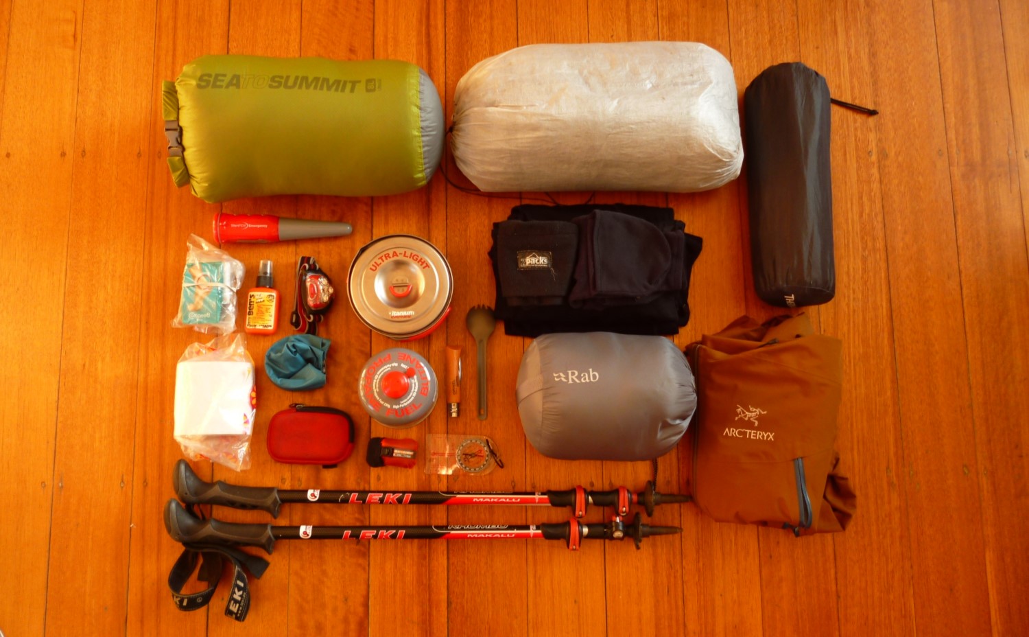
If you are heading to Pakistan and planning to do some hiking, then check out our gear related content:
Otherwise if you enjoyed reading this destination guide then you'll likely love reading about other inspiring destinations, such as:
Happy endeavours out on the trail!
The epic Nanga Parbat at night, as seen from the campsite at Greenland Hotel in Fairy Meadows.

Keen To Browse Outdoor Kit?
Check out our Gear Reviews overview page. Or focus in on one of these awesome review sections:
Ready To Start Building Your Dream Kit List?
In our Ultimate Gear Lists section we provide a list of best-in-class items for specific outdoor adventures. Get inspired by checking out our:
Gagging To Get To The Outdoors?
Find a jaw-dropping location for your next wilderness adventure by checking out our epic Destination Guides! How about: