Pyrenees High Route (HRP) Hiking Guide for 2023
JUMP TO: PROS & CONS / ITINERARIES / COMPARISON WITH GR10 & GR11 / CAMPSITES & HUTS / WHEN TO GO / MAPS & GUIDEBOOKS / ANIMALS / WHAT TO PACK
Author: Sam Brilleman
The Pyrenees High Route (Haute Route Pyrénées, HRP) is a long distance hiking trail that follows the mountainous divide along the French-Spanish border. These grandiose mountains are home to some of the most dramatic scenery in all of Europe.
The 497 mile (800 km) long HRP trail follows the backbone of the mountain range all the way from the Atlantic Ocean in the west to the Mediterranean Sea in the east. On average it takes about 45-50 days to complete. Since many hikers are unable to spare the time, expense, or effort necessary to thru-hike the entire trail, we suggest an alternative 5-6 day itinerary below that covers some of the most stunning sections of the trail.
PROS
Long distance trail incorporating some of the most dramatic mountain scenery in Europe
Extensive network of huts
Wild camping (mostly) allowed
Relatively easy resupply
CONS
Roaming farm animals
Less wildlife than many North American wilderness areas
Regular thunderstorms in the warmest months (July/August)
Short hiking season (mid-June through Sept)
POSSIBLE ITINERARIES
PYRENEES HIGH ROUTE (HAUTE ROUTE PYRENEES, HRP)
LENGTH: 497 miles / 800 km
DURATION: 45 days
TYPE: One-way
START: Hendaye, France
FINISH: Banyuls-sur-Mer, France
BEST TIME: July & August
The Pyrenees High Route - also known as the Haute Route Pyrenees (HRP) - is an unmarked long distance trail traversing the upper reaches of the Pyrenees mountain range. The HRP is not an official trail and consequently there are several potential variations on the route. The most common is the one popularised by Ton Joosten's Cicerone Guidebook "The Pyrenean Haute Route".
Although a high mountain route, the HRP does not require any technical skills such as mountain climbing, rock climbing, or glacier travel. During the peak summer months, from late June to early September the entire route can be traversed without crampons or any specialist gear. Nonetheless, there are numerous mountain passes to cross, and so you should at least be comfortable with crossing snowfields, as well as terrain such as boulders and scree. And as always when travelling in the mountains, you should be prepared for any weather conditions.
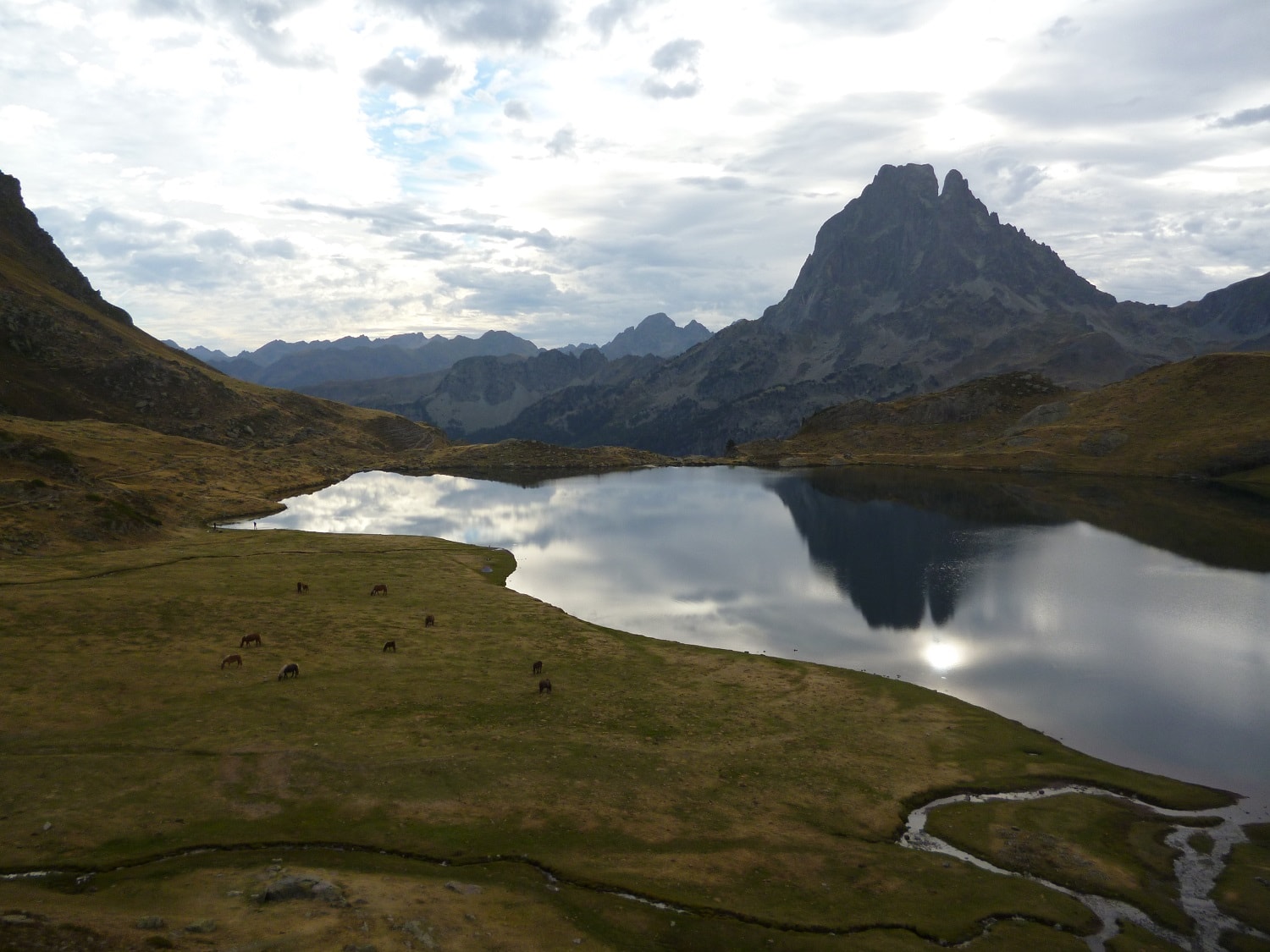
Wild horses are a common sight in the Pyrenees mountains — Here they are from the lake in front of Refuge d'Ayous with the Pic du Midi d'Ossau in the background.
In general, it is recommended to walk the HRP from west to east. This is the direction described in most guidebooks. Travelling west to east means that easier, flatter, terrain is encountered first. In addition, it means that many of the ascents over passes in the higher part of the mountain range can be completed in the morning before the sun rises over the eastern side of the ridge.
Lastly, travelling west to east means there is a higher chance that wind and rain is blowing into your back, rather than your face. Of course, the choice of direction is somewhat arbitrary and down to personal preference.
Wild camping under the dramatic north face of Vignemale.
SUGGESTED 5-6 DAY ITINERARY
LENGTH: 45 miles / 72 km
DURATION: 5-6 days
TYPE: One-way
START: Etsaut, France
FINISH: Cauterets (Pont d’Espagne), France
BEST TIME: July & August
The following 5-6 day itinerary takes you along one of the most impressive sections of the Pyrenees High Route (Haute Route Pyrénées), as well as some beautiful sections of the GR10 and GR11. It takes in some of the most dramatic mountain scenery along the entire Pyrenees range. If you only have a week or so available, then this route — or some variation on it — is highly recommended.
You can plan to start your hike in the small French village of Etsaut. This village has some accommodation and food options, but they are few, so we suggest planning ahead. Etsaut can be accessed by bus from Bedous, which in turn can be accessed via a small branch train line from Pau. The city of Pau has a mainline train station servicing the major centres of southern France including Toulouse, Lourdes-Tarbes, and Biarritz-Anglet-Bayonne, all of which have international airports. Train and bus timetables can be found on the French railways (SNCF) website. There are only a few bus connections to Etsaut each day, so plan ahead.
From Etsaut follow the GR10 (direction east) up to Refuge d’Ayous, where you can connect with the HRP. Continuing east, follow the HRP through Refuge de Pombie, Refuge d’Arremoulit, Refuge de Respomunso, and Refuge Wallon, spending as many days on this part of the trail as you see fit.
Looking back towards Ibon de Arriel Alto, located between Refuge d’Arremoulit and Refuge de Respomunso.
From Refuge Wallon the HRP continues east over the Cauterets Pass to Refuge des Oulettes de Gaube. Spend a night at, or camping near, Refuge des Oulettes de Gaube — this is a beautifully located refuge with dramatic views of Vignemale’s north face. If weather allows, consider the day hike to the top of Vignemale - it can be accessed from the top of the Cauterets Pass.
If you wish to end your hike here, then from Refuge des Oulettes de Gaube you can follow the GR10 down the valley to Pont d’Espagne. You are afforded impressive views while walking down the valley. Note however that this section of the GR10 is only a few hours walk from the spa & ski town of Cauterets (on the French side of the Pyrenees), so it is popular with day hikers or those renting a car to explore Europe.
From Pont d’Espagne, you can either catch a bus or walk down the road to Cauterets. Cauterets provides an ideal place to conclude your hike as it has many comfortable accommodations as well as bus services heading for larger towns in France.
View heading down the valley towards Pont d’Espagne on the French side of the Pyrenees
If you would prefer to conclude your hike on the Spanish side of the border - or if you wish to add a couple of days onto your hike - then consider the following alternative. Instead of heading down the valley from Refuge des Oulettes de Gaube, you can instead head back over the Cauterets Pass and on to Torla.
Once over the Cauterets Pass, follow the Camino de Cauterets to its intersection with the GR11. At the intersection, follow the GR11 south-east past Refuge de Ordiso, through Bujaruelo, and then on to Torla. This will add about a day and a half of walking onto your hike.
Torla is a beautiful little village that has some accommodations, food, and bus access to other towns and cities on the Spanish side of the Pyrenees. Torla also provides access to the dramatic Ordessa Valley, which is a side / day trip you may wish to consider.
Of course finishing on the Spanish side of the Pyrenees opens up the opportunity to explore other parts of Spain, or perhaps even further afield to Portugal.
The view back to the dam near Refugio de Respomuso — Respomuso is one of the staffed huts on the Spanish side… serving cooked three course meals & beer… f**k yeah!
COMPARISON WITH GR10 & GR11
It is worth noting that the Pyrenees are home to two other long distance trails: the French GR10 and Spanish GR11. Both of these trails also follow the Pyrenees mountains for their entire length. However, the GR10 and GR11 each remain exclusively on one side of the French-Spanish border, travel at a lower elevation, and are well marked. Whereas the HRP trail constantly hops back and forth across the border, follows the highest part of the mountain range, and is not officially marked.
These features of the respective trails mean that the GR10 and GR11 are generally more suited to hikers who wish to have nightly access to facilities (e.g. accommodation and food) found in the villages at the foothills of the mountains. On the other hand, since the HRP remains on the top of the mountain range, it is more suited to those hikers seeking a wilderness experience (e.g. camping or staying at mountain huts). The HRP also provides more dramatic mountain scenery due to it's higher elevation.
CAMPSITES / HUTS
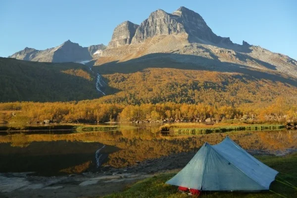
Travelling in the European mountains usually entails access to both serviced and unserviced huts. Hiking in the Pyrenees is no exception. In theory, it would be possible to plan carefully and walk the entire 800km HRP without carrying a tent. However, we would not recommend it. Our preference is to carry a tent. With a tent you have greater flexibility, more solitude, and you also have a shelter in case of emergency.
You should generally carry cash with you, since it may be the only way to pay for accommodation and/or supplies at the huts.
CAMPING
Wild camping is allowed throughout the Pyrenees, so long as you only stay for one night and steer clear of villages, buildings, and access roads. Generally, you will find established campsites around each hut or refuge on the French side of the border as well as around some of the huts on the Spanish side. You may see signs asking you to only set up camp from 7pm in the evening and to leave early in the morning, but I wouldn’t worry too much about these as long as you are only staying one night.
HUTS
There is an extensive network of huts in the Pyrenees mountains. These range from free unserviced huts to fully-serviced and staffed huts serving three course meals. Unstaffed huts do not require a reservation and there is usually space available on arrival.
Staffed huts vary in terms of the services they provide. Some staffed huts simply have a guardian there to monitor the hut and manage reservations, but do not provide any food or supplies. On the other hand, some staffed huts provide a full service including the sale of hot meals and basic supplies. Note that the more popular staffed huts require booking in advance and may be full in the peak summer season. Refer to the recommended guidebooks below for more details.
WHEN TO HIKE THE PYRENEES HIGH ROUTE
The main hiking season is from late June through September. From mid-July through August you should be able to complete the entire HRP without traction devices. In late June and/or early September you may need traction devices (e.g. crampons) to traverse some of the higher mountain passes.
In the central part of the mountain range daytime temperatures generally range between 70-80°F (21-27°C) with nighttime temperatures between 25-35°F (1-7°C). Of course, temperatures can vary greatly depending on local altitude and weather. Closer to the coast the temperatures are generally warmer, whilst in the higher central part of the mountain range the temperatures are colder.
In the warmest months afternoon thunderstorms can be a daily occurrence. If you are travelling in late July or August then you should plan to be off the higher mountain passes and ideally in camp by 4pm since this is the time afternoon thunderstorms generally begin.
As with any high altitude mountain range, fog, wind, rain and snow are all real possibilities at any time of year, so plan and prepare accordingly.

MAPS / GUIDEBOOKS
GUIDEBOOK
The best guidebook currently available (as at 10/3/2018) is Ton Joosten’s Pyrenean Haute Route, published by Cicerone Press. This book has detailed information on each section of the trail, as well as useful information to help with planning. Trail sections are described in a manner that can allow a hiker to travel hut to hut, if you so wish (we prefer the flexibility offered by wild camping). Each trail section is accompanied by the expected travel time as well as a difficulty grade, however, no mileage is included.
MAPS
Rando Editions publish a set of 25 topographic maps at 1:50,000 scale covering the entire HRP. These can be purchased online from Omnimap (in the US) or Stanford’s (in the UK), but be wary that it is unlikely all 25 maps will be in stock so you need to plan ahead. Moreover, each map will set you back about US$20 excluding postage (as at 10/3/18) so unless you only require one or two of the maps, the cost may become prohibitive.
An alternative, and much cheaper option, is to download and print map sections from an online topographic mapping website such as Caltopo.
ANIMALS (...AND THE NOT SO "WILDLIFE")
For those travelling from outside Europe, it is worth noting that even the upper reaches of the European mountains are well accustomed to farming. And the area through which the Haute Route Pyrénées travels is no different. When heading up a scree slope towards a mountain pass or setting up camp near a mountain lake for the night, it is not uncommon to encounter sheep, cattle or horses.
These roaming animals will be sharing the mountains with you for the duration of your hike, and may come as a surprise to some - particularly for hikers from North America, where wilderness areas are generally found to be home to slightly more wild forms of animals such as bison, moose, elk and bears.
Due to the significant number of grazing animals in the Pyrenees mountains, we suggest treating any water you collect from streams and creeks. The possible exception is when you are in the uppermost reaches of the high Pyrenees, and feel certain that no animals would have been grazing upstream from where you are. For our favourite forms of water treatment, check out the gear guide below.
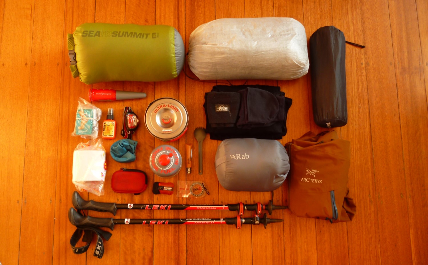
WHAT TO PACK FOR THE HRP
This gear guide includes the items we think you should be carrying with you on the HRP. However, if you want detailed gear reviews then check out our backpacking gear reviews section or our ultimate backpacking gear list.
Remember that the Pyrenees are big mountains. Historically — due to farming etc — they are more heavily travelled than many mountain ranges in, say, parts of North America. Nonetheless at times you will be very isolated in the high Pyrenees and the weather is changeable. You should be self-reliant. This includes having adequate shelter (unless you plan to travel hut to hut), warm insulated clothing, and waterproof and windproof rain gear.
RAIN GEAR
Ok, we may have encountered mostly sunshine on the HRP! but if the weather turns against you, then you are going to want good quality rain gear.
Rain jacket: Carry a jacket that is both waterproof and windproof (not just “water resistant”). Lightweight options that provide adequate protection include the Arc’teryx Zeta FL (7.2 oz), Montane Minimus Jacket (7.5 oz), or Patagonia Storm Racer (6 oz). A slightly heavier but seriously weatherproof option is the Arc’teryx Beta LT (12.2 oz).
Rain pants: Rain pants are vital to staying warm (and dry!) in a mountain storm. Rain pants with ankle zippers are often the lightest, but they are sometimes difficult to get on over boots and have almost no ventilation. Full length or 3/4 length zippers are heavier, but they can be partly unzipped from the top to provide ventilation and are easier to get on over your shoes or boots. The Outdoor Research Helium Pants (6.5 oz, ankle zipper), Berghaus Paclite Pants (8.0 oz, 3/4 length zipper), and Mountain Hardwear Stretch Ozonic Pants (10.0 oz, full length zip) are all good options.
Gloves or mittens: We always recommend packing waterproof gloves or mittens. You can probably survive a bad storm without them but you might be very uncomfortable. We carry a pair of fleece flip top mittens along with a waterproof shell mitten. The two best ultralight shell mittens currently available are the Montane Minimus Mitt (1.55 oz) and the Zpacks Vertice Rain Mitts (0.71 oz).
BASELAYERS
For baselayers you should always avoid cotton! Opt for merino wool or synthetics instead — you can read our post on merino wool vs synthetics here.
A merino t-shirt is moisture wicking, good in both warm and cold climates, and naturally odour resistant. It has been my first choice for all my hiking outings, including on the HRP.
Baselayers (underwear): For underwear we suggest the Smartwool Merino 150 Boxer Briefs for men, and the Smartwool Merino 150 Bikini and Icebreaker Meld Zone Sports Bra for women. But opt for whatever you find comfortable — see our Best Hiking Underwear for Men or Women for more info.
Baselayers (upper): We opt for a merino t-shirt specifically the Smartwool Merino 150 T-Shirt. We also carry a Smartwool Merino 250 Quarter-Zip Top for layering. It performs well and the zip allows us to regulate our temp.
Additional baselayers (long johns and/or shirt): You will want a spare pair of merino or synthetic thermal underwear for sleeping. We carry a pair of lightweight merino bottoms and merino long sleeve top. We suggest the bottoms as a minimum, but whether you take an additional long sleeve top just for sleeping might depend on your backpacking style.
OTHER CLOTHING
After all, this is the mountains and the weather can be extremely changeable. So you’ll want a good quality down (or synthetic) insulated jacket.
Insulating jacket: Down jackets are the best choice for an insulating top layer since down provides unbeatable warmth for weight. Our favourite down jacket is the Rab Electron, but if you want something thinner and lighter then consider the Patagonia Micro Puff Hoody. If you’d prefer a synthetic jacket (they have a lower warmth-to-weight ratio, but retain warmth when wet) then our favourite is the Arc’teryx Atom AR Hoody.
Warm hat, gloves and neck warmer: We love the Zpacks Micro-Fleece Hat — its ultralight but still warm. For warm gloves we opt for a pretty generic Fleece Flip-Top Mitten. We also carry a Smartwool 150 Neck Gaiter — it provides significant warmth for its weight.
Hiking pants or shorts: We tend to use lightweight nylon convertible pants, like the Columbia Silver Ridge Convertible Pants. Summer daytime temperatures can get pretty hot on the HRP, so it is great to have the versatility of both shorts and pants in the one package. You aren’t going to be “bushwacking” in the Pyrenees, so opt for pants that are lightweight and quick drying (i.e. you don’t need something heavy and tough!).
Hiking socks: We use the Bridgedale Wool Fusion Ultralight Socks. You should choose socks that are relatively light and breathable, but will provide sufficient warmth for your personal preferences. We carry one pair for hiking and one pair for sleeping.
Sleeping socks: A spare pair of hiking socks can be used for sleeping. Alternatively, if you sleep cold, then PossumDown Bushman's Friend Socks or even Goose Down Booties are warmer options.
Sunhat: Speaks for itself really. You’ll need one in these mountains!
FOOTWEAR
These beasts are the Boreal hiking boots I wore when hiking a section of the HRP back in 2012. Having now opted for going lightweight, I would never recommend footwear this chunky!
A breathable pair of trail runners or lightweight hiking shoes are likely to be your best choice for hiking in the Pyrenees. Trail runners dry quickly when wet, are less likely to give blisters, and are generally more comfortable. But if you feel more comfortable in a pair of hiking boots then go with that.
Gore-Tex is probably overkill for the HRP since much of your hiking is in the upper mountains where daytime temps are warm, mud isn’t a significant issue, and unbridged stream crossings are relatively rare.
Hiking shoes: These days I use the La Sportiva Ultra Raptor Trail Running Shoes and I love them! They are comfortable, breathable, stable, and super grippy.
Camp shoes: Some people also like to carry a pair of lightweight sandals or shoes for evenings in camp or in the refuges (huts). This comes down to personal preference.
SHELTER
We used a tunnel tent on the HRP, but these days we opt for a Zpacks Triplex — it is seriously lightweight, more spacious, and has two vestibules instead of one.
If you are camping, then you will need a tent or other shelter (e.g. tarp). Parts of the high Pyrenees are very exposed, so your tent should be able to withstand high winds and heavy rains. A tent with a large vestibule that can be used for cooking is also useful.
Tent: Our favourite tent is the Zpacks Triplex, but the Big Agnes Tiger Wall UL2 is another great lightweight option that is slightly cheaper.
More info: Best Backpacking Tents.
SLEEP SYSTEM
Sleeping bag: If you want to go lightweight then a backpacking quilt would be an ideal choice for the HRP in summer. However, if you sleep cold, then a sleeping bag like the Feathered Friends Lark would be a good choice. If you want something a bit cheaper but still high quality then check out the REI Co-Op Magma 15°. More info: Best Sleeping Bags, Best Hoodless Sleeping Bags, Best Backpacking Quilts.
Sleeping pad: We believe the best sleeping pads are inflatable air pads. They are lightweight and much more comfortable than traditional closed-cell foam pads. The Therm-a-Rest NeoAir XLite would be our recommended pick for the HRP — it provides the ideal balance between warmth and weight. If you sleep cold though, then consider the Therm-a-Rest NeoAir XTherm. More info: Best Sleeping Pads.
Pillow: A backpacking pillow such as the Sea to Summit Aeros Premium can seriously improve your sleep quality and doesn’t need to weigh much. More info: Best Backpacking Pillows.
BACKPACK & GEAR STORAGE
Back in 2012 on the hRP Anita and I were both lugging around heavy canvas backpacks. These days I wouldn’t dream of it! Go for a lightweight backpack.
Backpack: The size of your backpack will depend on a number of factors including the gear you are carrying, whether you are camping or staying in huts, and your backpacking style. Nonetheless, most people require a backpack with between 40 and 60 litres of volume.
Opt for a lightweight backpack — modern lightweight backpacks are just as comfortable and durable as traditional backpacks with a heavy frame.
Our favourite lightweight backpack is the Zpacks Arc Haul Zip — its ultralight, feature rich, and almost fully waterproof. More info: Best Backpacks, or check out some eco-friendly backpack options.
Dry sacks: Don’t both with a rain cover for your backpack. Instead, store your clothing and other vital gear (e.g. sleeping bag) in dry sacks. The Sea To Summit Ultra Sil Dry Sacks are our favourites. They are ultralight, waterproof, and the colours are useful for sorting gear.
CAMP KITCHEN
Stopping for lunch in the valley just south of Pont d’Espagne.
Cooking equipment: Although some of the staffed huts serve meals, many others do not.
We therefore suggest carrying a stove + fuel, lighter, cooking pot(s), and spork. And perhaps also a bowl or cup, if you wish. More info: Ultimate Backpacking Gear List - Kitchen.
Pocket knife: The Opinel No. 6 Stainless Steel Pocket Knife is our favourite — it is both cheap and reliable. More info: Best Pocket Knifes.
WATER TREATMENT
Due to the significant number of grazing animals in the Pyrenees we suggest carrying water treatment of some form.
Water purifier: Our favourite form of water treatment is the SteriPEN Adventurer Opti. Note that the SteriPEN is a water purifier and not a water filter. It doesn’t actually remove any particulate, rather it scrambles the genetic makeup of any bacteria or viruses so that they can’t replicate and therefore cannot make you sick.
Water filter: If you prefer a water filter then the Sawyer Squeeze is a great lightweight option.
OTHER EQUIPMENT
It’s always a good idea to carry a map and compass!
Map & compass: We always suggest carrying a map and compass, especially on the HRP where several sections are unmarked. See above for detailed info on maps and guidebooks. Our favourite compass is the Suunto M-3 D Leader.
Headlamp: Our favourite is the Petzl Actik Headlamp.
Trekking poles (optional): We love them! And wouldn’t do a multi-day hike without them. They also serve as our tent poles. Check out the Leki Micro Vario Carbon for high-end quality, the REI Co-Op Flash Carbon for all round value, or the Gossamer Gear LT5 for ultralight.
Bathroom: Bug spray, toothbrush, toothpaste, soap (for hand washing), sunscreen, lip balm, toilet paper, blister plasters, first aid essentials, lightload pack towel (optional).
Electronics (optional): Camera, e-reader, GPS, personal locator beacon.
TRAVEL INSURANCE
Thought about travel insurance for your trip?
Although hiking isn’t generally considered a high risk activity, we believe it is always a wise idea to have adequate travel insurance in case things go wrong. Not just when hiking, but on any holiday or trip! Accidents do happen, and travel insurance saves you the financial stress if a drama does hit.
Without a doubt our go-to travel insurer is World Nomads.
They keep things simple by having only two types of plans: Standard and Explorer.
Their Standard Plan has plenty of coverage for emergency and non-emergency medical expenses and covers a large list of adventure activities, including hiking and trekking. However their Explorer Plan does have a few additional benefits that might make you consider it.
The key differences between their plans are:
The Explorer Plan covers an additional number of very high risk adventure sports and activities that aren’t covered under the Standard Plan — see here for the full list of activities covered or not covered under each plan.
The Explorer Plan increases cover for baggage and personal effects to $3000, whereas the Standard Plan only has a total of $1000 cover for baggage and personal effects (which isn’t much).
The Explorer Plan has $35,000 cover for rental car damage, whereas the Standard Plan has absolutely no coverage for rental cars or other vehicles.
The other upside of World Nomads is that they allow you to extend your insurance if you decide to extend your trip — something many other companies strangely don’t allow.
Check out the link below for more info. And always be sure to read the policy details yourself before purchasing, to make sure it’s the right choice for you.
MORE INFORMATION
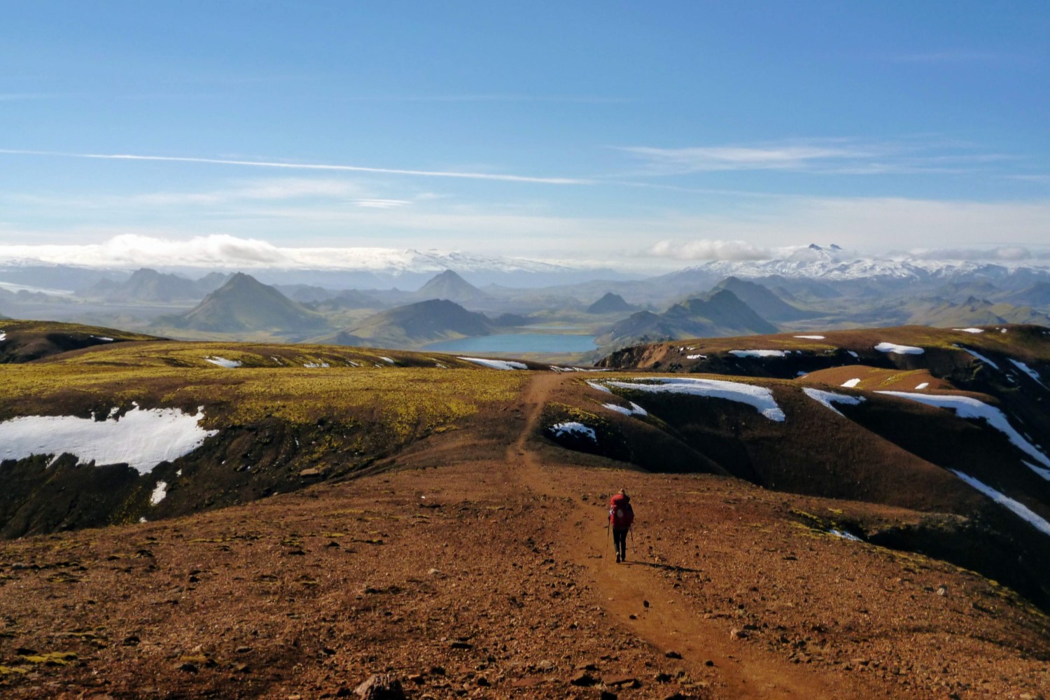
Looking to get hiking somewhere off continental Europe? Then check out our guide to the Laugavegur Trail in Iceland or perhaps take a hike on the less travelled Arctic Circle Trail in Greenland.
Alternatively you might love reading about other inspiring hiking destinations around the globe:
Happy hiking and take care out there in the wild!

Keen To Browse Outdoor Kit?
Check out our Gear Reviews overview page. Or focus in on one of these awesome review sections:
Ready To Start Building Your Dream Kit List?
In our Ultimate Gear Lists section we provide a list of best-in-class items for specific outdoor adventures. Get inspired by checking out our:
Gagging To Get To The Outdoors?
Find a jaw-dropping location for your next wilderness adventure by checking out our epic Destination Guides! How about: